Thursday, June 26, 2025

Waterfall Wonders

Sue and I had a couple of days together to get the house set up for the excitement of our arriving visitors; our son Grant and his wife Kaileen flew to Seattle on Sunday, June 21, where they were greeted by Kaileen's parents, Greg and Glenda, who had arrived as tourists a day earlier.

Greg had rented a car and met Grant and Kaileen at the airport in the morning, they toured Seattle's Pike Street Market, the Chihuly Glass Art Museum and did some wine tasting before driving the 50 miles north where we had a pot roast supper waiting for them.

I had laid out some options for places of interest in the Pacific Northwest; they had prioritized nature and pleasant hikes with an emphasis on scenic waterfalls and woods. I looked them in the eye and told them, "I will make that happen. Follow me!"

In the morning I took them up the road about 25 miles to the Boulder River Wilderness Trailhead. Plenty of woods to begin with and a promised beauty of a waterfall after an easy 1.2 mile trail.

Boulder River Wilderness Trailhead
Greg, Glenda, Sue, Kaileen & Grant


We examined the geology of the bedrock, the plants and gnarly tree roots and exchanged convivial chatter and before we knew it, standing before us was the unnamed forked waterfall was rushing over the precipice on the other side of Boulder River.

Embraced within the folds of a massive cedar tree on the Boulder River Trail

Sue and Mark share roots


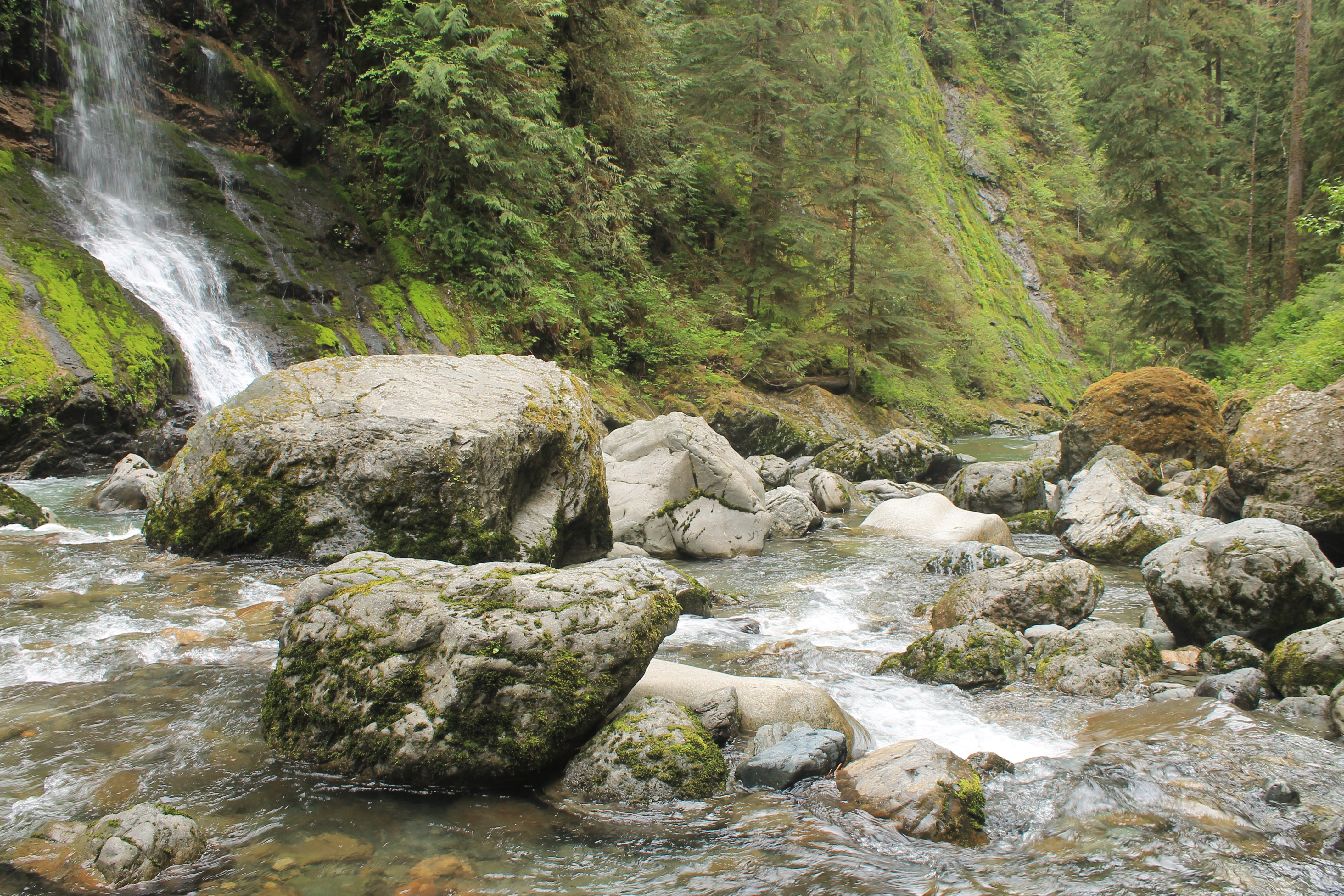
Rounding the trail that followed the contour of the steep slope, the waterfall (which I feel should be named 'Dragon Tongue Falls') came into view. We all scrambled off the trail and down the rough slope to walk and hop among the boulders of Boulder Creek at the base of the falls.

Kaileen & Grant at trail's end for Dragon Tongue Falls


***

We hiked back to our cars at the trailhead where we discuss our plans. It was decided to grab some lunch at the Burger Barn in the small town of Darrington a few miles further up the road.


After lunch, "Anyone interested in another waterfall?" 

I explained it was a rather short hike to see North Fork Sauk River Waterfall, a full-blast, roaring waterfall, in contrast to the flittering, tranquil essence of our morning's first waterfall experience. In answer to my question, it was a resounding, "Yes!"

We traveled in tandem over about 16 miles of unpaved seasonal road know as The Mountain Loop Highway. 

The springtide flood and volume made for a spectacular sight.


The roaring North Fork Sauk River Falls

Sue silhouetted against the backdrop of an impressive waterfall 

Grant and Greg managed to scramble over the rocky, semi-blazed trail to stand on the bedrock at the base of the falls. Kaileen, being the social media poster extraordinaire, got some great shots of the place to post to her friends and adventure followers.

***

It was mid-afternoon, and I had a suggestion. Since we've come this far, how about we finish this Mountain Loop of a so-called highway, and go see a series of waterfalls cascading into an avalanche shoot piled high with the winter's snow where the water carves out an ice cave at the base of Big 4 Mountain?

Wheeling over the pothole pocked dirt road that is the Mountain Loop Highway, we crossed over Barlow Pass, leaving the Sauk River watershed and descended into the Stillaguamish River watershed and some spectacular views of some of the peaks of the Cascade Range. We parked at the Big 4 Mountain lot where once stood a grand hotel, until it burned to the ground in 1938.

Walking along the path to the trailhead, a busy beaver was spotted hauling a 3-inch diameter piece of wood and paddling through the one of its beaver mash waterways.

Beaver viewing from a boardwalk above the marsh at Big 4 Mountain


It was enjoyable hike through marsh, across an aluminum bridge and into the woods where several redheaded woodpeckers were spotted. We were warned by signs not to enter the ice caves as there were at least four different ways in which one could die; killed by falling rocks, killed by collapsing ice, killed by falling through an ice crevasse, or killed by an avalanche.


At the end of the trail, we viewed the ice caves beginning to form at this early stage of the seasonal melt, from a safe distance. I was tempted to challenge fate and get closer, as I think was Grant, but in deference to our wives, we held back our adventurous exploration.

A stern warning from the US Forest Service

Sue with avalanche chute and waterfall at Big 4 Mtn


With a good day's worth of waterfalls collected in our minds, we passed through Granite Falls and headed back home. We called in an order for some Greek-style pizza for pickup on our way home. 

We estimated (using their cell phone tracking) that we hiked between 7 and 8.5* miles in our treks to see Pacific Northwest waterfalls.

*Different devices had different estimates.

We kicked off our boots, devoured our pizza dinosaur-time style and opened a few brews in the long-lasting evening light of this latitude.

"What do ya got for us tomorrow, Mark?" Someone asked.

"We've done mountains today, let's do sea and saltwater and The Islands tomorrow. We'll take it easy, relax on a ferry boat ride to San Juan Island and Friday Harbor."

Sounds good. See ya in the morning. Goodnight.

Friday, June 20, 2025

Like Spawning Salmon, We return


Like spawning salmon, we return...


At the entrance to Ivar's Salmon House, Seattle
March 28, 1986 - June 18, 2025

Ah, I remember it well...

Well... maybe I sorta remember some things from 39 years ago. 

I definitely remember feeling rather giddy and comfortably wonderful about my wedding scheduled for tomorrow. The rehearsal had gone well, my best men, Paul Gold and Chalmer McClure had goofed around, we posed for a few eccentric photos wedged into the formal rehearsal space at University Presbyterian Church in The U-District in Seattle.

With places, timing and roles all discussed, practiced and memorized, it was time for everyone in the wedding party to join us at Ivar's Salmon House for the pre-nuptial dinner on the shores of Lake Union, under the shadow of the towering I-5 Ship Channel Bridge. The food was good, the company was great, as I remember it.

It is an interesting exercise to skip through all the twists and turns that our life has shared in the years since we first dined at Ivar's; I find myself having built a new, whimsical house on the 50 acres on which my bride was raised. As fate would have it, I am mostly living in our Washington house, while my bride is living at our house in Texas where we raised our kids and spend the majority of our lives the past 35 years.

It is exciting that for a few weeks this summer of 2025, we will be reunited under the roof of our House on the Pilchuck. And in a few days, we will begin to welcome family to our house as well. Just as it had always been planned and as it should be.

Susan, my bride flew into Seattle from Dallas on June 18, landing early evening. She lands, but her cell phone (these miraculous thing had not been invented when we arrange to get married back in 1986) was not responding or dialing out. Something to do with the settings or maybe battery life. Oh, the frustrations of relying on miraculous devices.

I parked at the airport, studied the digital board of flight arrivals and noted that her flight had landed. Hoping she made her flight, I had to assume she would be somewhere inside the Seattle airport. I hung out at the baggage claim carousel paired with her flight - no bride in sight. I wandered among the madding crowds for about a half hour and found my lost (or runaway) bride shuffling through the deplaned passengers outside the TSA perimeter.

I hugged her from behind. She tried to offer an explanation as to her mysterious silence, but my lips were on hers, and so she could not really talk like a girl would want to.

We sorted things out. She had checked her carry-on bag, so we waited for it to be offloaded at Baggage Claim 14. We started to catch up with each other in person as I directed her into the cavernous parking structure to search for my vehicle.

It was around 7 PM Pacific Time, translating to 9 PM her stomach time. The eventual question came up, "Do you have an idea or plan for dinner?", she asked.

"How long have you known me? And yet you ask if I have a plan for dinner? My, we've been apart for far too long."

I exited north bound I-5 at the end of the Ship Channel Bridge and made a few extra byzantine turns through the confusing, non-orthogonal streets of this waterside Seattle neighborhood, looking for Ivar's Salmon House.

I had to ask, "Do you think Ivar's is back behind us - or should I go further down this road?"

"I think we passed it. I seem to remember it being closer to the bridge." My wife was right, of course. A reconnection with my working phone-based GPS confirmed her instincts. 

I spun the wheel around and Viola! We we right back where we both started on that glorious pre-nuptial night of March 28, 1986. We had returned. It was so fun and fitting to take my bride back to Ivar's Salmon House now that we were together in Seattle. It was just like I remembered it...

Like salmon, we return to the waters from which our journey had begun so long ago. It was good.  

About to be married - Fun in Seattle

After a night at Ivar's Salmon House
We get the married the next day.


Saturday, June 14, 2025

Barlow Point

 The paved portion of the Mountain Loop Highway runs east out of Granite Falls, following the course of the South Fork of the Stillaguamish River until it reaches Barlow Pass. There, at the summit of Barlow Pass, the pavement ends and the road descends to the drainage of the Sauk River flowing north.

Peak rising east as seen from the top of Barlow Point

At the summit there is a trail to Barlow Point that advertised great panoramic views of both the Stillaguamish and Sauk watersheds far below. I thought I'd give it whirl since it was only 1.2 miles and the map showed a straight dotted line from trailhead to the vista point.

This trail was not flat, but it was climb over rocks and tree roots from the get go and it seemed much further than the 1.2 mile one way trip; I had to wonder if the distance was measures as the crow flies and did not account for the numerous switchbacks needed to gain the elevation to the top of the ridge. 

It was all uphill, all the way. One foot in front of the other. It took this old man 1 1/4 hours to climb the 1 1/4 miles. It was kind of a beating, but once I started, I wanted to finish and not be defeated by the mountain's contours rising above me. It was 4 PM when I started, I knew I had about 5 hours of daylight left, but...  This climb was tougher than I expected.


The trail was heavily forested all the way.

Hiking up the trail, my heavy legs estimated 118 switchback traversed before I got to the top, and I though maybe I'd gained 1200 feet in elevation. I counted the switchbacks on the way down - there are only 39. And checking the map at the trailhead, the elevation gain was 800 feet.

Made it to the top of Barlow Point.
Stillaguamish River watershed behind me to the west.

Shadowed peaks to the west at 5:30 PM

Cheery colors await me on the rocky top of Barlow Point.


My ascent was hard on the lungs. My descent was hard on the knees. My heart was happy to have made it to the top of Barlow Point and happy to have made the solo trek back down the side of the mountain.

I pointed my 4Runner downhill toward Granite Falls and pulled into the Thai House Restaurant, ordered Kee Mao, a chicken dish with pad Thai noodles, basil, ginger and peppers plus a pot of hot jasmine tea. A good day.

Friday, June 13, 2025

Big 4 Mountain Ice Cave

Big 4 Mountain on Mountain Loop Highway
Outside Granite Falls

 My glorious plan for the warming months of May and into June here in Washington, was to get out with my 4WD machine and explore the sights and hikes in my backyard. I'd made my first foray in May up to Darrington to scout the Mountain Loop Highway, a 55 mile partially paved car trail that links the Cascade Mountain towns of Darrington and Granite Falls with plenty of hikes into the mountains, around lakes and beside rivers and streams. I'd finished my trip to Darrington, but the MLH had yet to be opened for the season - opening estimated for around Memorial Day.

I return home to The Pilchuck from my north-end scouting trip only to have by transmission destroyed when the drain plug inexplicably rattled out, leaking all of the essential tranny fluid and stopping my forward progress. Twenty-three days later after being in solitary confinement with no transport, my 4Runner was returned with a rebuilt transmission. Eager to make up for lost time, I drove to Granite Falls on the south end of the Loop to head back into the Cascades to explore.

At the top of my list was the Big 4 Ice Cave. Big 4 Mountain, so named because its eastern face has a set of fractures that form the numeral 4 when seen in the spring and summer as the white snow-filled fracture contrasts with the dark rock. At the base of Big 4 Mountain is a talus field and large avalanche shoot that accumulates a delta shaped mound of snow. In the summer and fall, one of the numerous waterfalls which feeds into the top of the snow pile at the base of the avalanche shoot, hollows out an ice cave opening the water flows through the pile of ice at the base of the mountain.

An element of danger awaits at the end of the trail
At least five people have been killed this century by collapsing ice or rockfalls at the end of the trail. I believe most hikers disregard the danger and approach the base of Big 4 Mountain. I understand the allure, but I stayed on the trail at a safe distance as advised.


The trail from the picnic area is 1.1 miles (one way) to the ice cave. It is an easy hike, with modest elevation gain and expansive boardwalks that cross the marsh created by generations of beaver in the beautiful alpine valley. 


A large-leaf plant grows in the marsh. 
US Forest Service build boardwalks
make the marshland passable.

From the parking area one can see a handful of tiny, lacy ribbons of water cascading over the steep face of the mountain. I was eager to get a closer look, telling myself, I should not tempt fate and get too close to the danger zone at the base of the mountain where tumbling rocks or ice can smash one's head in an instance. 

The view and the end of the trail did not disappoint.


It was too early in the season for significant ice cave to have been hollowed out at the base of the accumulated avalanche snow and ice delta. But if you look close, you can see a small ice cave beginning to form at the leading edge. The cave will be enlarged through summer and fall by the action of the flowing water feeding into the snow from above.


Tuesday, June 3, 2025

You Ain't Goin' Nowhere


Clouds so swift

The rain won't lift

My gate won't close

My gears all froze

You Ain't goin' nowhere.

I've been sentenced to 18 days in solitary confinement. 

I'm a condemned man, I took the rap, served my time despite my innocence. Life isn't always fair.

It seems like half an eternity ago, but it was May 18th, the 45th anniversary of Mount St. Helens eruption...

Give me a mountain that blows

and truck that goes,

Oh no, You ain't goin' nowhere.

...I was motoring into Stanwood when I came to that hill that I always climb - no matter how steep, should've bought a jeep, before I get to town. And she just whined and didn't have the power to scoot on up. Something was not right.

Ooh, wee, Ride me high...

You ain't goin' nowhere.

I pulled over, the 'check engine' light flashed on, I knew I was in trouble. 

Ooh, wee,

You ain't goin' nowhere.

I got a lift back to my place, leaving the 4Runner on a Stanwood side street. I got back to town Monday morning and had her towed to a shop with a good reputation. I left my name and number at the counter with the ignition key. They said they were backed up with work and they would have a look as soon as they could. What could I do? I ain't goin' nowhere any how.

A couple of days later I hear from the shop; "Your transmission drain plug is missing. All of your tranny fluid drained out, you don't have the use of all your gears - it's unsafe to drive. Your transmission is damaged, we just don't know how bad."

I'm told that they don't rebuild transmissions, but they could take it out and look at it. Then they could order a rebuilt transmission and get it back to me by June 6 and it would cost me a little north of $9 grand. They recommend that I have JT's Transmission take a look at it.

I call the local Toyota dealership. They quote me labor and parts for a bit more than $5,000 - but they can not give me a date as to when they could get those parts in. Maybe a week, maybe a month - who knows? 

I call JT. He tells me around $5500 for a rebuild and he can have it done before the end of May. I get the 4Runner towed a second time, delivered to JT's shop.

***

It's now June 3, 2025. Things have not gone so swift, the clouds won't lift, I haven't gone anywhere. I haven't been off of my place for 18 days. I'm in solitary confinement. Fortunately I went to Costco the day before my drain plug rattled out and fried my transmission. I'm well enough stocked for food. But no face-to-face company. No contact with the locals. 

I kill time during this house arrest, by landscaping. I cut fallen alders for firewood, I trim the long, tall grass springing up around me covering my field, I tend my flower bed and realize I'm just raising fodder for the multitude of slugs. 

Then I realize that May 24th is Bob Dylan's birthday. I listen to Dylan. I relate to his tune, 'You Ain't Goin' Nowhere'.

I'll need to get my 4Runner back before June 18th when...

Ooh wee, that's the day my bride's gonna come,

Ooh wee, are we going to fly

Down into the easy chair!

If I got my transmission with all it gears, I'll drive down to the Seattle airport to pick up my bride. Ooh wee, ride me high!

Then on June 22nd, Grant, Kaileen and her parents will a come for a visit. I'm excited to show them around these parts.

Buy me some gears that grind

Hopin' for waterfalls and beaches to find

Ooh wee, Ride me High!

Now we're goin' somewhere!


Thursday, May 15, 2025

North Fork Sauk Falls - Cascade Mountain Loop Highway


The Mountain Loop Highway takes me 16 miles south of Darrington where I come to a fork in the road. As Yogi Berra supposedly advised: If you come to a fork in the road - take it. And that I did. Veering left, I followed the sign pointing toward North Fork Sauk.

After 1.1 miles, rounding a bend in the dirt/mud road, I came to a non-descript wide spot with a post and a place where a sign was once attached, painted in US Forest Service brown. Navigating by instinct, I believed that this was the place where I had intended to be. Backing into the assumed parking place, I hopped out from behind the wheel, listened to the violent roar of water somewhere downhill, grabbed my rucksack and found a small trail into the brush. Obviously, a little-known, out-of-the-way kind of site that appeals to me.

A few steps into the misty, dripping woods, I could see signs of an established trail. I was confident I had found the last point of interest for my day's exploration. North Fork Sauk Falls must be down the trail from here.

The trail's descent was rather steep. The path was overgrown, yet easy to follow. The descent to the falls was maybe only a third of a mile, but I had to watch my footing on rotted wooden steps that were slickened by the ever-wet forest slime.


Emerald pool at the base of North Fork Sauk Falls


The violent, continuous roar of the falls was deafening. A dense cloud of mist rose thick from the base of the falls, wafting into my nostrils and covering all the ferns and foliage surrounding my viewing platform carved from the cliffside. I was most impressed by the multi-sensory experience of this location's sound and fury and feel of the cold spray of dews and damps embracing my flesh.

The bedrock outcrops across from the falls were worn smooth, rounded and sensual, while rocks next to the torrent were angular. An interesting juxtaposition of textures than caught my entranced eye as I again marveled at the fierce nature of this powerful spectacle.

***

I could go no further on the Mountain Loop Highway at this time of the season. I headed back to Darrington and linked back to State Highway 530 that would return me to Arlington, and then to my home gate.   

Too Early for the Mountain Loop Highway

 I was back with my trusty steed [4Runner] at the Boulder River Trailhead a little past noon. The sky was cool and gray, but no rain. I took that as a good omen and decided to make a day of it and drive into Darrington and catch the Mountain Loop Highway, a mostly unpaved  55 mile road that connects with Granite Falls.

I stopped by the Darrington Ranger Station to inquire about getting a Forest Pass, a $5 day pass that permits the holder to access trails and amenities in the Mount Baker - Snoqualmie National Forest Recreation Area. 

The good news: My Life Time Senior Citizen Dept. of Interior National Park Pass doubled as a Forest Pass. Just hang the plastic insert that holds my NP Pass from my rear view mirror and jump off into the wilderness and explore the Mountain Loop Highway. No additional pass needed. I'm paid up in full!

The bad news: The Mountain Loop Highway is not yet open for the season. The route is closed along the highest elevation at Barlow Pass in the middle of the loop. The contractor showed up on Monday and is clearing the fallen timber from the road and grading it for summer traffic. It should be opened around Memorial Day.

I asked Ranger Erika, "How far can I get right now and what is there for me to see along the way?" She suggested that I could check out the confluence of the Sauk and White Chuck Rivers at the parking area there and then she recommended that I continue on up to view the North Fork Sauk Falls. She said that it should be flowing a good clip right now, a spectacular and surprising sight. Ranger Erika then added that when she has out-of-town visitors, she takes them to see the North Sauk Falls.

I put my SUV in 4-wheel drive and headed out of Darrington - which didn't take long and then ran out of pavement. I stopped at the kayak boat launch at the Sauk and White Chuck River confluence and briefly looked around.


White Chuck River flows from the left into the channel of the Sauk River

Sand bar on the Sauk River provides easy access for those who wish to 
run Class 2 & 3 rapids between and over the streambed boulders of the Sauk River.


Back in 4WD mode and up the mountain on the unpaved Mountain Loop Highway - 'highway' actually is a misnomer, more like a mildly potholed car trail through heavy woods. Adventurous and doable for the average vehicle even without 4WD and high-clearance.

I pulled over at the White Chuck Mountain Overlook, and as is so often the case in the Pacific Northwest; "...now, if you could see through those clouds, you would be treated to see..."

Such was the case as I looked at a raft of clouds snagged by the peaks of the mountains across the valley, one of those cloud-shrouded peaks would have been White Chuck Mountain. I had hopes that my viewing experience of the North Sauk Falls would be more impressive than this intermediary stop.

White Chuck Mountain Overlook. 
I got a nice view of some tree and a low, gray sky obscuring the majestic mountain peaks.

***

It was mid-afternoon and I had not packed a lunch. But I had a plan; at the end of my day of exploration in the rugged Cascades, I'd be back to Darrington for a Swiss mushroom cheeseburger, fries and a big black raspberry milkshake at the quaint, roadside attraction; Darrington's own Burger Barn. 

Darrington's own Burger Barn with a large option of milk shake flavors and a host of burger combos.

Yum! 

And so it was, an early dinner, or a late lunch at 4:30 before heading back down the mountain to my estate on The Pilchuck.

Forked Falls on Boulder River Hike

Forked waterfall plunges into Boulder River

The weather forecast claimed that the rain would hold off until mid-afternoon on Thursday, May 15th. Time enough, I figured to do a little exploration in my own back yard.

I swung the gate closed and rolled up the road toward the mountain town of Darrington. I covered the 24.5 miles that brought me to the turn off to the Boulder River Trailhead in 30 minutes, arriving at 10 AM. I had high expectations that I could visit a mesmerizing, unnamed forked waterfall rushing over the rockface rising for a hundred feet or more above the Boulder River.

Boulder River Trailhead. I was the first one on the trail this morning.

After a 3.6 mile drive up a decent (at least the first two-thirds of the way) dirt road, I parked as the only vehicle at the trailhead this morning. I tossed my rucksack on my back, stuffed with a camera, raingear and several bottles of water and was off for a scenic mountain adventure. I could hear the roar of Boulder River in the distance and far down the mountain as I closed the SUV door. The trail peters out in about 8 miles, but the point of interest, a majestic, split waterfall was only a 30-40 minute hike with moderate elevation gain.

The beginning of the trail is a wide and level grade, having once been a narrow gauge railroad built to extract timber in the early 20th Century.


The trail is lined with a wall of fern as one ducks under fallen timber that lays above the trail on the steep mountain slope into which the trail is cut. I am amazed that I find myself now living in a place that is so eye-slammingly green. Moss is thick and spongy and grows on rocks, trees and on those that do not move quickly down the trail. As I round the mountain, the roar of Boulder River far down-slope gets louder and I get a few glimpses of the rapids from on high. 

Large fir trees cling to boulders on the steep slope above the river


The wide, level trail reaches the Wilderness Boundary where no logging was permitted within, and the easy railroad grade trail now yields to a narrower path hewn into the old growth wilderness with a moderate, rocky ascent into the woods above Boulder River.


I was expecting my boots to be kicking across a terrain of dark andesite or dacite igneous intrusives, but I puzzled that underneath all of this moss and tenacious tree roots were slopes not of igneous rocks, but of metasedimentary rocks in hues of grays, greens and blacks and a few dun patches to boot. 

A boulder-strewn channel carves the narrow river ravine at the base of the northwest face of 125 foot cliff with a gorgeous double waterfall in view between the tall timber. A fast-flowing stream rushes over the precipice, cascading through two vertical channels lined with vibrant green moss.


Boulder River fed by an unnamed forked waterfall


Forked falls framed by a moss covered forked tree.

There was about a 40 - 50 foot scramble off the trail to clamber down to the river's gravel bank. The descent was steep, utilizing strategic jutting stone steps and a few horizontal logs as footholds. 
The scramble off the main trail,
descending to the Boulder River at the 
base of the forked falls 

It was worth it. 

I could have lingered and enjoyed the cacophonous serenade of kinetic waters colliding as I sat alone in the cool, misty mountain air for much longer. I climbed back up to the main trail for a peek at what might be ahead on this trail. 

I ventured further up the trail beyond the waterfall to see if another spectacular sight might behind around the bend and in view between the trees. Trapsing across a fallen log fitted with handrails spanning a deep ravine, I covered perhaps another mile, took a few photos of some of the wildflowers growing the the mountainside.


But I had a few other hikes and sights planned up the road. So, I turned around on the Boulder River Trail and set the toes of my boots pointing toward the Mountain Loop Highway, a mostly unpaved car path through some deep woods and mountain passes the connects the Cascade Mountain towns of Darrington with Granite Falls.