My life, it's a life filled with crazy duality.
From January through most of April; I was a Texan. I lived with a girl in Texas, I cooked for her, I did major home maintenance for her place in Texas, I planted a pecan tree in our Texas front yard.
Come April, I'm back on the road heading to the Northwest to re-adopt my wildman of the Pacific Northwest woods persona.
I'm now back in my house on 50 acres of tall cedar, fir and alder with plenty of thorny blackberries covering the land. Back on The Pilchuck I still have some interior home furnishings to upgrade and there is always some landscaping to do.
Come June of this year, I'm excited to host our first guests on this yet-to-be grand estate. Son Grant, his wife Kaileen and her parents will join Sue and me on The Pilchuck and the end of June. I've listed for our future guests a full itinerary of Pacific Northwest options; hiking on volcanoes, exploring the Cascade Range, sailing on the Washington State ferries out to the San Juan Islands, dining on oysters in a restaurant suspended form a cliff over Samish Bay, trouncing through wild iris and rose bushes in the tidelands to a secluded beach. Some of these itinerary items I've already done; others I know about, but have not experienced first hand.
It is a fine day Tuesday, May 5th. Quite warm for Western Washington standards. I stow my machete and spraying rig for controlling the thorny berry canes and declare that today is a day for me to leave the home chores and to scout North Cascades National Park. I will want to see what I can recommend for my guest later this summer.
 |
| Entrance to North Cascades NP, "The American Alps" |
It is about 90 miles from my gate up into the section of the Cascade Range designated as a National Park, a park that has relatively few visitors and is mostly unknown to the American public. A little on-line research gives me some options for a couple of day hikes and a list of shorter hikes, pleasant walks almost, that are available around Newhalem. I decide to start with a 2.2 mile hike along Thunder Creek to a bridge that spans the glacier-fed waters and allows hikers to go another 2.5 mile further to Fourth-of-July Pass for a spectacular view of the jagged, snow-capped peaks within the park.Thunder Creek Trail (to the bridge) ~4.5 mile roundtrip:
 |
| Trailhead for Thunder Creek |
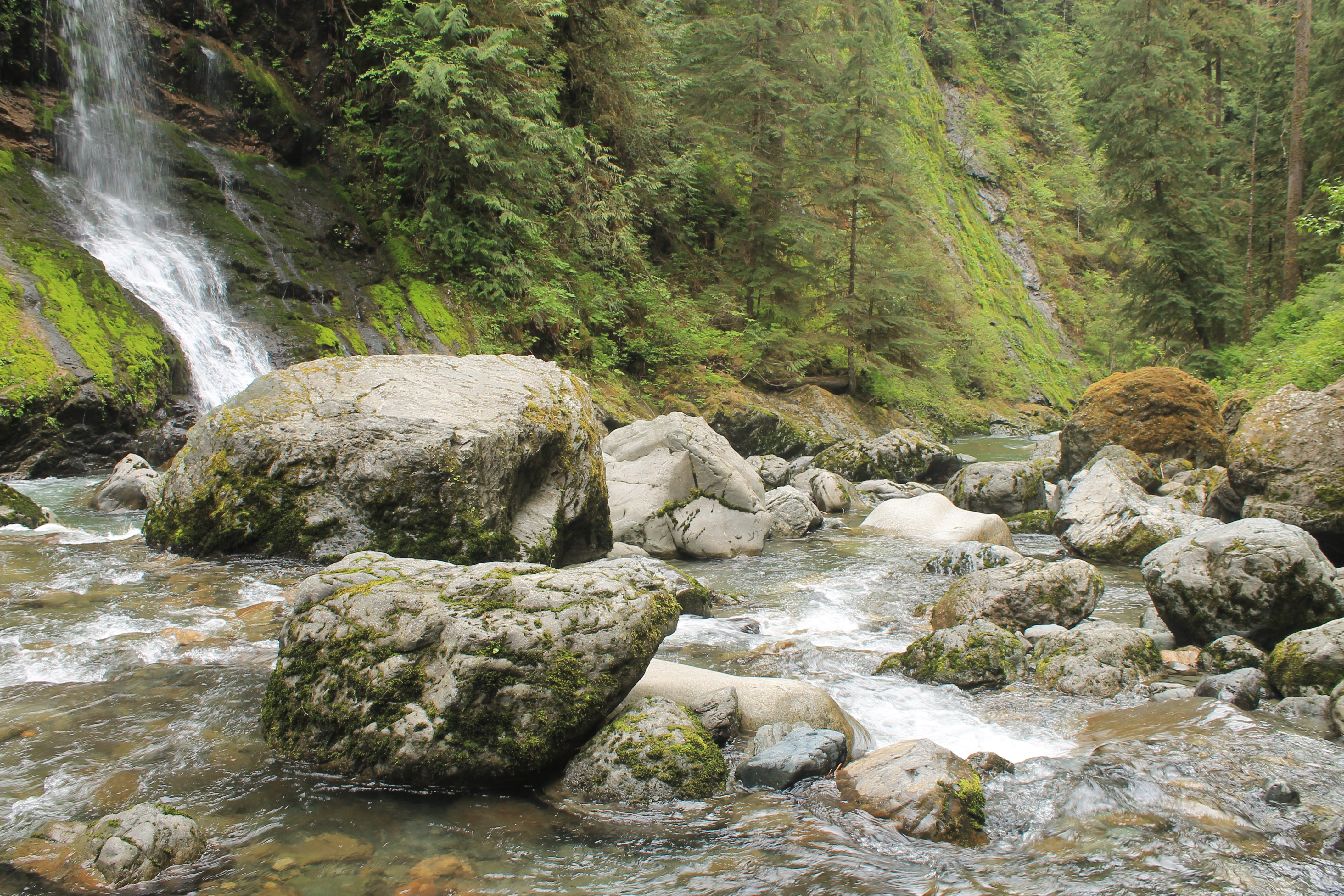
Thunder Creek trail is about as level of a mountain hike as one could ever expect. It took me about 45 minutes to hike the 2.2 miles to the bridge. The trail is cut along a steep slope on the banks of Thunder Creek, which has an aquamarine hue that I find to be an exceptionally beautiful color of water. This color is due to 'glacial flour', very fine sediment from glacially ground rock that imparts this mesmerizing color when carried in the stream's flow. |
| Thunder Creek from the bridge at 2.2 miles |
Thunder Creek Trail did not offer spectacular vistas (unless one continued another 2.5 miles to Fourth-of-July pass), but it was a typical Pacific NW experience to walk beneath large evergreens, under fallen logs covered in thick carpets of green, spongy moss and a few stops to marvel at the salt-and-pepper [dacite] igneous rock slides that cross the trail and underpin this magnificent terrain. It was a well-shaded, easy hike that gives a great feel for being in the forest primeval, with a variety of interesting plants and flowers along the way.
 |
Firs, ferns and fallen timber on Thunder Creek Trail
|
 |
An outcrop of dacite igneous intrusive that was
split asunder by an ancient Sasquatch family and used for shelter by these
mythical apes of the Pacific NW forests |
 |
| The bridge over the aquamarine waters of Thunder Creek |
 |
| A very large spruce cut down at the Thunder Creek Bridge approach |
 |
| My lunch spot next to the rushing, clear waters of Thunder Creek |
It took me about 45 minutes to get to my destination, Thunder Creek Bridge, 2 1/4 miles up the trail. I stopped for lunch and enjoyed watching an American Dipper, a robin-sized bird that flies and dives into the rapids, stays submerged and then bobs up to fly away.There were animal tracks in the sand bar at the river's edge; I think they might be coyote.
 |
| Hi! I'm a fun guy. |
I considered hiking on to the pass with a clear alpine view of rugged, snowy peaks another 2.5 further up. But I calculated that if I did that extension of this hike, I would finish at the end of the day, and I wanted to explore a couple more short hikes further down the mountain in Newhalem area.
 |
| Hi! I'm a fungi. |
Along the trail there were interesting historical indications of early 20th Century logging in the old growth forest all about. These trees are so tall that loggers had to cut notches in the base of the tree to insert springboard planks on which to stand as they cut the trees down with two-man saws. These planks gave the lumberjacks a surface on which to stand above the thicker base of the tree.
The notched on the side of one of the trees just so happened to look like a wise ol' face in in the forest. Makes me think of the Ents on Tolkein's Lord of the Rings.
My wife, a native of these part, has long enjoined me to be on the lookout for a special floral delight, the trillium. Finally, I do believe I found Sue's trillium along the Thunder Creek Trail.
Gorge Creek Overlook
Leaving Thunder Creek, I headed back down the mountain and stopped a viewing spot to look 150 feet beneath my feet at Gorge Creek as I stood on the highway bridge walkway made of a thin steel grid that one can look straight through. I am not particularly afraid of heights - but I have to admit, I felt a tinge queasy imagining the long drop to the rocks below this gridded walkway platform on which my feet were planted. Still, Gorge Creek, a spectacular cataract.
 |
| Gorge Creek cataract from high on the bridge |
 |
Gorge Creek flows into Gorge Lake.
Gorge Lake is formed behind the first of three hydroelectric dams. |
The Skagit River flows through North Cascades NP, though maps show that the river valley is not part of park land, it is dedicated to three hydroelectric dams on the river that were built from 1924 through 1962 to provide electricity to light the City of Seattle.
A recent forest fire burned through the area, the dead trees are evident on the steep ridges in the Gorge Creek and Newhalem areas.There is a short loop trail at the Gorge Creek viewing pullout that lets one walk to get a peek at Gorge Lake behind the first hydroelectric dam. One could descent the trail and get to the dam and I believe their are tours available at the Gorge Dam.
 |
| Gorge Lake |
Newhalem Short TrailsNewhalem is a village that houses the workers who operate the hydroelectric generators for Seattle City Lights Corporation. Newhalem has a store, the Gorge Inn, and a visitors center and few short trails in the area.
Trail of Cedars: 1 mile Interpretive Trail
 |
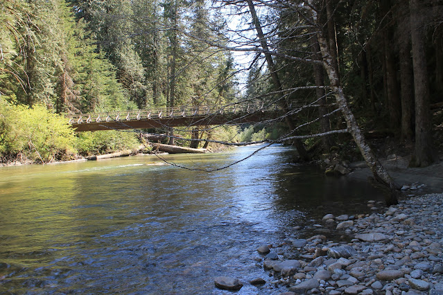
Pedestrian suspension bridge over the Skagit River
|
The Trail of Cedars begins by crossing a pedestrian suspension bridge over the Skagit River and leads to a easy and level loop trail that has many informative signs placed by the University of Washington Forestry School to educate those along the trail as to what types of trees are before them and why they are growing there as well as other interesting phenomena and conditions to be noted by the observant hiker.
 |
'See-Through Tree'
A living tree hollowed out by fire |
There is a spot on the trail named 'the children's castle', where some children in 1922 were playing with candles inside a group of large, hollow trees, when their candles ignited the tree's chimney-like interior and caught the crowns on fire. The local fire company's ladder and hoses could not reach the flames at the tops of the trees, so the firemen had to cut the trees down to keep the flames from spreading, and extinguish the fire once the burning trees were laying within reach on the forest floor.
Ladder Creek: Rock Garden & Pothole Falls Trail
Behind the power house on the Skagit River, is a small tributary, Ladder Creek.

|
| Gorge Dam Power House on the Skagit River |
Another pedestrian suspension bridge crosses the Skagit River and provides access to view the potholes at Ladder Creek Falls. A series of winding steps that ascend the hill on which once stood a fabulous rock garden built to awe the visiting public with the wonder and promise of an industrial American future now available with the harnessing of the river to generate electricity. Not only did the Gorge Dam light the streets of Seattle, but to showcase the marvelous possibilities of an electrified 20th Century, a rock garden was built that had electrically heated planter beds that grew exotic tropical specimens such as banana trees right here in the Cascade Mountains of Washington. The trail through the exotic plants was illuminated by the marvel of electric lights, shining 'in all the colors of the rainbow' as phonographic music played through hidden electric speakers. Visitors delighted to strolled under the beautiful light show while accompanied by music throughout the garden, long before Rock 'n roll theatrics were ever staged.
The Ladder Creek Rock Garden, though not much by today's standards, was once a glorious monument to the optimism and the benevolent industrial might of America.
 |
Bridge to the Rock Garden
|
 |
| Potholes at Ladder Creek Falls |
The Rock Garden still exists, though the man-made wishing pools and are dry and the exotic tropical plants are long gone, replaced by native and well adjusted species. Seattle City Lights Co. has restored the evening light show along the trail to Ladder Creek Falls with LED colored lights from dusk to midnight - if anyone wanted to hang around that late in Newhalem.
Certainly not the most stunning of gardens, but an interesting little walk in what was 100 years ago a truly magical sight to see, as Americans innovated and banished the darkness with electric lights, available at the mere flick of a switch. We forget how essential and beneficial electricity is to our lives.

 |
| Wooden bridge through the Rock Garden |
 |
| Rock Garden in May Flower Blooms |


